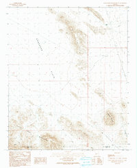
1990 Map of Little Horn Mountains NE
USGS Topo · Published 1990About this map
The Ranegras Plain dominates the western half of this arid landscape at the border of La Paz and Yuma counties. In this 1990 provisional survey, the terrain transitions sharply into the Little Horn Mountains and the distinct peak of Deadman Mountain in the southeast. This area is defined by its isolation and sparse desert infrastructure, where survival and utility are marked by features like Talon Tank, Twin Tanks, and a lone Guzzler. The influence of early 20th-century ranching and mineral exploration is visible through the presence of a Corral and several scattered Prospects located along the southern mountain slopes. Drainage patterns are clearly delineated, most notably by Deadman Wash, which carves through the Nottbusch Valley as it descends from the high ground.
Find a feature on this map
12 named features on this map. Tap any name to fly to it.
Don’t see what you’re looking for? This feature index may not catch every label — zoom into the map to look around manually.
Map Details
Editions of this 1990 Little Horn Mountains NE Map
This is the sole edition of this map. No revisions or reprints were ever made.
Other maps of this area

1942 · Vicksburg
USGS Topo · 1:250,000

1954 · Phoenix
USGS Topo · 1:250,000

1957 · Phoenix
USGS Topo · 1:250,000

1958 · Phoenix
USGS Topo · 1:250,000

1960 · Phoenix
USGS Topo · 1:250,000

1961 · Hope
USGS Topo · 1:62,500

1961 · Lone Mountain
USGS Topo · 1:62,500

1962 · Little Horn Mts
USGS Topo · 1:62,500

1962 · Eagletail Mts
USGS Topo · 1:62,500

1969 · Phoenix
USGS Topo · 1:250,000