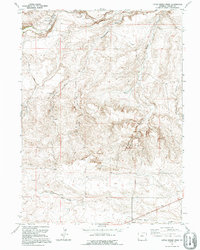
1991 Map of Little Indian Draw
USGS Topo · Published 1995About this map
Horse Creek and Sprager Creek cut through the high Laramie County terrain in this 1991 snapshot of eastern Wyoming. The landscape is defined by its drainage patterns and isolated ranching infrastructure, such as the Lower J H D Sheds and Little Indian Camp. These labels, along with the settlement at Kirkbride, reflect the long-standing livestock and agricultural footprint of the region. The map provides a precise record of the network of draws, including Bullwhacker Draw and Little Indian Draw, which channeled seasonal water across the open range. In the southern portion of the quadrangle, Chivington Draw and Divide Camp further illustrate the distribution of named landmarks used by local ranchers to navigate this sparse and rhythmic topography.
Find a feature on this map
13 named features on this map. Tap any name to fly to it.
Don’t see what you’re looking for? This feature index may not catch every label — zoom into the map to look around manually.
Map Details
Editions of this 1991 Little Indian Draw Map
This is the sole edition of this map. No revisions or reprints were ever made.
Other maps of this area

1899 · Goshen Hole
USGS Topo · 1:125,000

1911 · Cheyenne
USGS Topo · 1:125,000

1914 · Cheyenne
USGS Topo · 1:125,000

1954 · Cheyenne
USGS Topo · 1:250,000

1958 · Cheyenne
USGS Topo · 1:250,000

1960 · Rocky Hollow
USGS Topo · 1:24,000

1963 · Little Indian Draw
USGS Topo · 1:24,000

1963 · Pole Creek Ranch SE
USGS Topo · 1:24,000

1963 · Midway
USGS Topo · 1:24,000

1963 · Midway SW
USGS Topo · 1:24,000