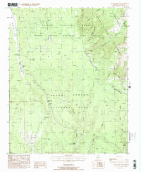
1988 Map of Little Park Lake
USGS Topo · Published 1988About this map
De Motte Park and the high plateaus of northern Arizona define this late-twentieth-century landscape, where the administrative boundaries of Kaibab National Forest and Grand Canyon National Park converge. The area serves as a critical transition zone between the managed forest lands of the Grand Canyon National Game Preserve and the protected wilderness of the Saddle Mountain Wilderness. A lookout tower stands watch over the timber, while the North Rim Entrance Station marks the transition into the national park.
Find a feature on this map
32 named features on this map. Tap any name to fly to it.
Don’t see what you’re looking for? This feature index may not catch every label — zoom into the map to look around manually.
Map Details
Editions of this 1988 Little Park Lake Map
This is the sole edition of this map. No revisions or reprints were ever made.
Other maps of this area

1886 · Echo Cliffs
USGS Topo · 1:250,000

1886 · Kaibab
USGS Topo · 1:250,000

1891 · Echo Cliffs
USGS Topo · 1:250,000

1903 · Bright Angel
USGS Topo · 1:48,000

1906 · Bright Angel
USGS Topo · 1:48,000

1907 · Vishnu
USGS Topo · 1:48,000

1953 · Grand Canyon
USGS Topo · 1:250,000

1954 · Nankoweap
USGS Topo · 1:62,500

1956 · Marble Canyon
USGS Topo · 1:250,000

1957 · Grand Canyon
USGS Topo · 1:250,000