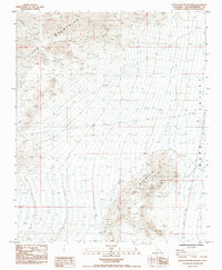
1985 Map of Little Piute Mountains
USGS Topo · Published 1985About this map
Piute Mountains and the Little Piute Mountains dominate this high-desert landscape in eastern San Bernardino County. Surveyed in the early 1980s, the map reveals a rugged terrain defined by sharp topographic relief and the expansive reach of the Ward Valley to the east. Human presence is sparse, marked primarily by industrial and utility infrastructure that cuts across the arid basins. A prominent Pipeline and a Trans Line Steel Tower corridor indicate the importance of this region as a transit point for resources and energy. Scattered throughout the northwestern ridges, several Prospects suggest historical interest in the area's mineral potential, while isolated water sources like the Guzzler serve as critical points for local wildlife in an otherwise punishing environment. The network of 4wd tracks provides the only access into the high-elevation terrain, highlighting the remote character of the Mojave landscape during this era.
Find a feature on this map
11 named features on this map. Tap any name to fly to it.
Don’t see what you’re looking for? This feature index may not catch every label — zoom into the map to look around manually.
Map Details
Editions of this 1985 Little Piute Mountains Map
This is the sole edition of this map. No revisions or reprints were ever made.
Other maps of this area

1942 · Amboy
USGS Topo · 1:250,000

1943 · Center Hills
USGS Topo · 1:62,500

1943 · Amboy
USGS Topo · 1:250,000

1943 · Essex
USGS Topo · 1:62,500

1943 · Fenner
USGS Topo · 1:62,500

1943 · Bannock
USGS Topo · 1:62,500

1954 · Needles
USGS Topo · 1:250,000

1956 · Needles
USGS Topo · 1:250,000

1956 · Fenner
USGS Topo · 1:62,500

1956 · Essex
USGS Topo · 1:62,500