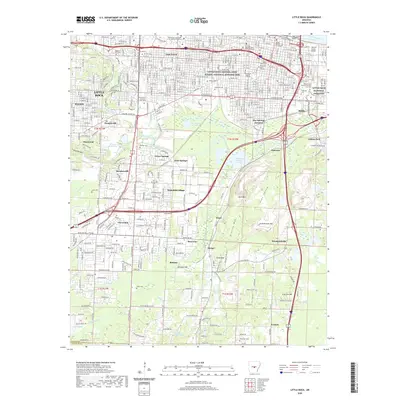
2020 Map of Little Rock
USGS Topo · Published 2020About this map
Little Rock Central High School National Historic Site stands as a focal point in this urban landscape, reflecting the city's complex social and educational history. The capital city's geography is defined by the Arkansas River to the north and a series of prominent peaks and ridges to the south and west, including Granite Mtn, Fourche Mtn, and Allis Mtn. This intersection of topography and development shows how the city expanded from its namesake, The Little Rock, into residential districts like Oak Forest and Wakefield Village. Extensive cemetery grounds such as Mount Holly Cem and the Little Rock National Cemetery occupy significant acreage near the city center. To the south, industrial and transportation hubs like Hot Springs Junction and the Big Rock Settling Pond reveal the city's infrastructure, while outlying communities like Woodyardville and Ironton mark the transition toward more rural Pulaski County.
Find a feature on this map
71 named features on this map. Tap any name to fly to it.
Don’t see what you’re looking for? This feature index may not catch every label — zoom into the map to look around manually.
Map Details
Editions of this 2020 Little Rock Map
This is the sole edition of this map. No revisions or reprints were ever made.
Other maps of this area

1891 · Little Rock
USGS Topo · 1:125,000

1893 · Little Rock
USGS Topo · 1:125,000

1935 · Mc Almont
USGS Topo · 1:24,000

1935 · Little Rock
USGS Topo · 1:24,000

1935 · Sweet Home
USGS Topo · 1:24,000

1935 · North Little Rock
USGS Topo · 1:24,000

1935 · Alexander
USGS Topo · 1:48,000

1940 · Woodson
USGS Topo · 1:31,680

1941 · Alexander
USGS Topo · 1:62,500

1943 · Pinnacle Mtn
USGS Topo · 1:31,680
Featured Places
- Little Rock, AR
- North Little Rock, AR
- Brittain, Little Rock
- Hot Springs Junction, Little Rock
- Fairview, Little Rock