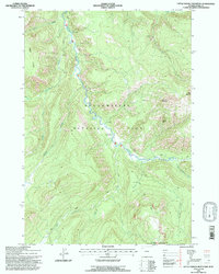
1991 Map of Little Saddle Mountain
USGS Topo · Published 1997About this map
The Lamar River carves a deep valley through this remote section of Yellowstone National Park, surrounded by the high-elevation terrain of the Mirror Plateau. The landscape is defined by its thermal activity, with several identified Thermal Areas positioned near the river's path and beneath the peaks of Little Saddle Mountain and Hague Mountain. Human presence in this wilderness is minimal, centered on a network of backcountry paths and the Cold Creek Patrol Cabin, which serves as a remote outpost for park management. The transition into the Shoshone National Forest North Absaroka Wilderness marks the eastern boundary, where the watershed is fed by numerous tributaries including Clover Creek, Mist Creek, and Buffalo Creek. This survey captures the region's hydrography and elevation before modern digital mapping, highlighting the navigational points used by rangers and trekkers alike.
Find a feature on this map
19 named features on this map. Tap any name to fly to it.
Don’t see what you’re looking for? This feature index may not catch every label — zoom into the map to look around manually.
Map Details
Editions of this 1991 Little Saddle Mountain Map
This is the sole edition of this map. No revisions or reprints were ever made.
Other maps of this area

1886 · Canyon
USGS Topo · 1:125,000

1895 · Canyon
USGS Topo · 1:125,000

1896 · Canyon
USGS Topo · 1:125,000

1896 · Crandall Creek
USGS Topo · 1:125,000

1899 · Crandall
USGS Topo · 1:125,000

1901 · Canyon
USGS Topo · 1:125,000

1907 · Canyon
USGS Topo · 1:125,000

1911 · Canyon
USGS Topo · 1:125,000

1955 · Ashton
USGS Topo · 1:250,000

1955 · Cody
USGS Topo · 1:250,000