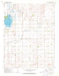
1971 Map of Little Salt Marsh
USGS Topo · Published 1972About this map
The Quivira National Wildlife Refuge dominates the western portion of this Kansas landscape, preserving a vital wetland environment centered on the Little Salt Marsh. Fed by Rattlesnake Creek and Horseshoe Lake, the refuge system represents a critical stopover for migratory birds in the Central Flyway. Just outside the refuge boundaries, the land transitions to the agricultural and extractive patterns typical of the Kansas prairie in the early 1970s. The eastern half of the map, particularly within North Hayes and Hayes, is dotted with numerous Oil Wells, indicating the region's reliance on petroleum production alongside farming. Local heritage is grounded in landmarks such as the Fairview Ch, Peace Creek Cem, and Hayes Cem, which mark the community centers and ancestral burial grounds of the families living along Peace Creek.
Find a feature on this map
18 named features on this map. Tap any name to fly to it.
Don’t see what you’re looking for? This feature index may not catch every label — zoom into the map to look around manually.
Map Details
Editions of this 1971 Little Salt Marsh Map
This is the sole edition of this map. No revisions or reprints were ever made.
Other maps of this area

1891 · Great Bend
USGS Topo · 1:125,000

1892 · Kingman
USGS Topo · 1:125,000

1892 · Pratt
USGS Topo · 1:125,000

1893 · Great Bend
USGS Topo · 1:125,000

1894 · Kingman
USGS Topo · 1:125,000

1894 · Pratt
USGS Topo · 1:125,000

1894 · Lyons
USGS Topo · 1:125,000

1955 · Great Bend
USGS Topo · 1:250,000

1955 · Pratt
USGS Topo · 1:250,000

1957 · Great Bend
USGS Topo · 1:250,000