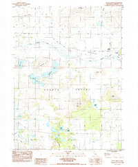
1984 Map of Little Shasta
USGS Topo · Published 1984About this map
Shasta Valley serves as the dominant landscape in this 1984 survey, where the Little Shasta River meanders toward its confluence with the Shasta River. The small settlement of Little Shasta remains a focal point for local history, supported by the Little Shasta Cemetery and a network of early thoroughfares like Little Shasta Road and Lower Little Shasta Road. These routes navigate a terrain of volcanic buttes and ridges, including Steamboat Mtn, Rabbit Hill, and the distinctive Owls Head.
Find a feature on this map
29 named features on this map. Tap any name to fly to it.
Don’t see what you’re looking for? This feature index may not catch every label — zoom into the map to look around manually.
Map Details
Editions of this 1984 Little Shasta Map
This is the sole edition of this map. No revisions or reprints were ever made.
Other maps of this area

1886 · Shasta
USGS Topo · 1:250,000

1894 · Shasta
USGS Topo · 1:250,000

1921 · Shasta Valley Sheet No 11
USGS Topo · 1:24,000

1921 · Shasta Valley Sheet No 6
USGS Topo · 1:24,000

1921 · Shasta Valley Sheet No 2
USGS Topo · 1:24,000

1922 · Shasta Valley Sheet No 12
USGS Topo · 1:24,000

1922 · Shasta Valley Sheet No 4
USGS Topo · 1:24,000

1922 · Shasta Valley Sheet No 5
USGS Topo · 1:24,000

1932 · Yreka
USGS Topo · 1:96,000

1934 · Macdoel
USGS Topo · 1:96,000