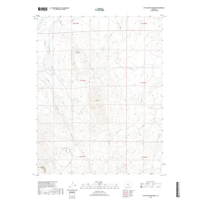
2019 Map of Little Sheep Mountain
USGS Topo · Published 2019About this map
Little Sheep Mtn and the larger Sheep Mtn anchor this high-elevation landscape along the boundary of Huerfano and Costilla counties. This 2019 survey captures a complex network of drainages that define the local topography, including the upper reaches of the Huerfano River and Pass Cr. The map reveals a transition from the wilder mountain slopes to the more developed lower elevations near the southern edge, where a cluster of residential roads including Houchin Blvd, Thompson Rd, and Parsons Rd appears. Water is the primary sculptor of this terrain, evidenced by numerous named tributaries like Spring Br, Oak Cr, and S Oak Cr that carve through the high-country peaks and valleys.
Find a feature on this map
27 named features on this map. Tap any name to fly to it.
Don’t see what you’re looking for? This feature index may not catch every label — zoom into the map to look around manually.
Map Details
Editions of this 2019 Little Sheep Mountain Map
This is the sole edition of this map. No revisions or reprints were ever made.
Other maps of this area

1889 · Huerfano Park
USGS Topo · 1:125,000

1892 · Huerfano Park
USGS Topo · 1:125,000

1954 · Trinidad
USGS Topo · 1:250,000

1955 · Trinidad
USGS Topo · 1:250,000

1958 · Trinidad
USGS Topo · 1:250,000

1959 · Trinidad
USGS Topo · 1:250,000

1963 · La Veta Pass
USGS Topo · 1:24,000
1963 · La Veta
USGS Topo · 1:24,000
1967 · Creager Reservoir
USGS Topo · 1:24,000
1967 · Russell
USGS Topo · 1:24,000