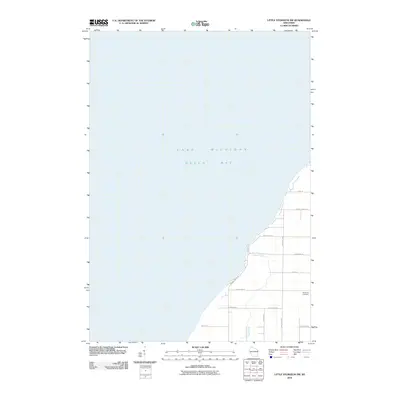
2010 Map of Little Sturgeon SW
USGS Topo · Published 2010About this map
Green Bay and Lake Michigan dominate this coastal survey of Door County, where the shoreline transition meets a grid of rural roads and scattered landmarks. The landscape is defined by the winding course of Sugar Creek, which flows westward toward the bay, cutting through a topography marked by a mix of agricultural plots and localized woodlands. Unlike many densely settled coastal areas, this portion of the peninsula remains relatively open, with its history quietly preserved at locations like the White Star Cemetery near County Hwy K. A network of thoroughfares including Brussels Rd, Lovers Ln, and 4 Corners Rd provides the primary infrastructure for this quiet section of Brussels, connecting farmsteads and local property lines just inland from the water's edge.
Find a feature on this map
16 named features on this map. Tap any name to fly to it.
Don’t see what you’re looking for? This feature index may not catch every label — zoom into the map to look around manually.
Map Details
Editions of this 2010 Little Sturgeon SW Map
This is the sole edition of this map. No revisions or reprints were ever made.
Other maps of this area

1952 · Casco
USGS Topo · 1:62,500

1954 · New Franken
USGS Topo · 1:62,500

1954 · Manitowoc
USGS Topo · 1:250,000

1956 · Oconto
USGS Topo · 1:62,500

1958 · Manitowoc
USGS Topo · 1:250,000

1961 · Little Sturgeon
USGS Topo · 1:62,500
1974 · Oconto East
USGS Topo · 1:24,000
1974 · Oconto SE
USGS Topo · 1:24,000
1974 · Peshtigo Harbor
USGS Topo · 1:24,000

1978 · Namur
USGS Topo · 1:24,000