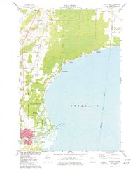
1974 Map of Oconto East
USGS Topo · Published 1977About this map
The city of Oconto serves as the focal point of this 1970s coastal survey, where the Oconto River empties into the waters of Green Bay. The landscape is a mix of municipal infrastructure and protected wetlands, notably the Oconto Marsh State Game Refuge and Ajax Island. Along the bay front, recreation and conservation efforts are evident through the North Bay Shore Recreation Area and Rush Point State Public Hunting Grounds.
Find a feature on this map
40 named features on this map. Tap any name to fly to it.
Don’t see what you’re looking for? This feature index may not catch every label — zoom into the map to look around manually.
Map Details
Editions of this 1974 Oconto East Map
This is the sole edition of this map. No revisions or reprints were ever made.
Other maps of this area

1939 · Marinette
USGS Topo · 1:48,000

1939 · Porterfield
USGS Topo · 1:48,000

1942 · Porterfield
USGS Topo · 1:48,000

1954 · Escanaba
USGS Topo · 1:250,000

1954 · Manitowoc
USGS Topo · 1:250,000

1956 · Oconto
USGS Topo · 1:62,500

1957 · Escanaba
USGS Topo · 1:250,000

1958 · Escanaba
USGS Topo · 1:250,000

1958 · Manitowoc
USGS Topo · 1:250,000

1961 · Little Sturgeon
USGS Topo · 1:62,500