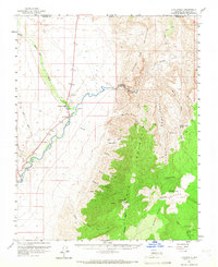
1954 Map of Littlefield
USGS Topo · Published 1966About this map
Littlefield sits at the vital junction where the Virgin River meets Beaver Dam Wash, serving as a focal point for settlement in the mid-1950s. This survey illustrates the convergence of northern Arizona, southern Utah, and Nevada, highlighting the arid landscape through numerous named springs such as Mountain Sheep Spring and Gates and Mullen Spring. The topography is dominated by the Beaver Dam Mountains to the north and the Virgin Mountains to the south, with notable heights at Mt Bangs. Researchers can trace the path of Highway 91 as it winds through the river valley, passing historical markers like Grave Cem and the Gaging Station. The map captures a high-desert terrain punctuated by deep drainage systems like Sullivans Canyon and Elbow Canyon, illustrating the importance of water sources in this dry borderland region.
Find a feature on this map
43 named features on this map. Tap any name to fly to it.
Don’t see what you’re looking for? This feature index may not catch every label — zoom into the map to look around manually.
Map Details
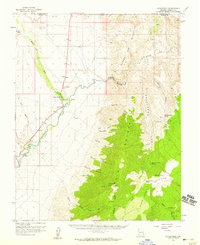
Editions of this 1954 Littlefield Map
2 editions found
Other maps of this area

1885 · St. George
USGS Topo · 1:250,000

1885 · Pioche
USGS Topo · 1:250,000

1886 · Saint Thomas
USGS Topo · 1:250,000

1886 · Mt. Trumbull
USGS Topo · 1:250,000

1886 · Pioche
USGS Topo · 1:250,000

1891 · St. George
USGS Topo · 1:250,000

1892 · Mt. Trumbull
USGS Topo · 1:250,000

1893 · Saint Thomas
USGS Topo · 1:250,000

1953 · Cedar City
USGS Topo · 1:250,000

1953 · Grand Canyon
USGS Topo · 1:250,000