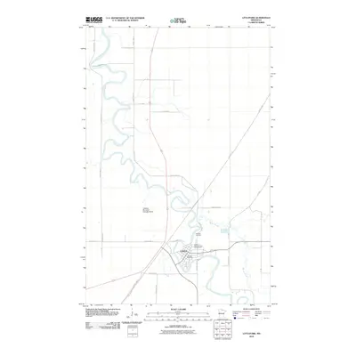
2010 Map of Littlefork
USGS Topo · Published 2010About this map
The Little Fork River dominates this northern landscape, carving a serpentine path through the terrain as it flows toward the settlement of Littlefork. This 2010 survey illustrates a community where the river remains the central geographic feature, with N River Dr and Electric Ave defining the local grid. Transportation and utility corridors, such as the Deer River Line and the long stretch of the Blue Ox Trl, slice through the surrounding forest and wetlands. Local infrastructure is well-documented, from the Littlefork Post Office in the village center to the Littlefork Municipal-Hanover Airport located just to the northwest. For those researching local heritage, the map identifies the Littlefork Cemetery and recreational spaces like the Lofgren Memorial Park Campground near the banks of Beaver Brook.
Find a feature on this map
27 named features on this map. Tap any name to fly to it.
Don’t see what you’re looking for? This feature index may not catch every label — zoom into the map to look around manually.
Map Details
Editions of this 2010 Littlefork Map
This is the sole edition of this map. No revisions or reprints were ever made.
Other maps of this area

1919 · Pelland
USGS Topo · 1:62,500

1919 · Happy Land
USGS Topo · 1:62,500

1919 · International Falls
USGS Topo · 1:62,500

1954 · International Falls
USGS Topo · 1:250,000

1957 · International Falls
USGS Topo · 1:250,000

1958 · International Falls
USGS Topo · 1:250,000

1969 · Ericsburg NW
USGS Topo · 1:24,000

1969 · Ericsburg SW
USGS Topo · 1:24,000
1969 · International Falls
USGS Topo · 1:24,000

1970 · Devlin
USGS Topo · 1:24,000