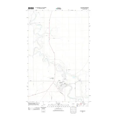
2013 Map of Littlefork
USGS Topo · Published 2013About this map
Littlefork serves as the central hub of this northern landscape, situated at the confluence where the meandering Little Fork River meets Beaver Brook. The settlement is defined by its grid of local streets like Main St and McPherson St, supporting a community anchored by the Po and the Littlefork Cem to the north. The river's winding path dominates the terrain, creating numerous oxbows and narrow peninsulas that shape the local geography and transportation routes. In the early 21st century, the area's infrastructure is marked by the presence of the Littlefork Municipal/Hanover Airport to the west and the Lofgren Memorial Park Campground along the riverbank, reflecting a balance between local utility and river-front recreation. Major regional arteries including Co Hwy-1 and MN-217 intersect here, connecting this river town to the broader Koochiching County region.
Find a feature on this map
26 named features on this map. Tap any name to fly to it.
Don’t see what you’re looking for? This feature index may not catch every label — zoom into the map to look around manually.
Map Details
Editions of this 2013 Littlefork Map
This is the sole edition of this map. No revisions or reprints were ever made.
Other maps of this area

1919 · Pelland
USGS Topo · 1:62,500

1919 · Happy Land
USGS Topo · 1:62,500

1919 · International Falls
USGS Topo · 1:62,500

1954 · International Falls
USGS Topo · 1:250,000

1957 · International Falls
USGS Topo · 1:250,000

1958 · International Falls
USGS Topo · 1:250,000

1969 · Ericsburg NW
USGS Topo · 1:24,000

1969 · Ericsburg SW
USGS Topo · 1:24,000
1969 · International Falls
USGS Topo · 1:24,000

1970 · Devlin
USGS Topo · 1:24,000