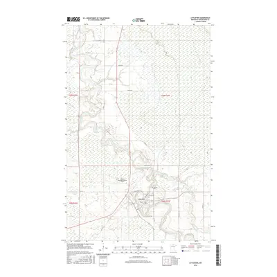
2016 Map of Littlefork
USGS Topo · Published 2016About this map
Littlefork sits at the dramatic confluence of the Little Fork River and Beaver Brook, serving as a vital hub in Koochiching County. The landscape is defined by the winding course of the river, which snakes through the northern Minnesota wilderness, creating complex oxbows and floodplains. Transportation in this era is anchored by a network of county and town roads, including Co Hwy 22 and Co Hwy 43, which connect the town center to more isolated homesteads and forested areas. Local infrastructure is evidenced by the Littlefork Municipal/Hanover Airport just west of the main settlement and the Littlefork Cem located near the riverbank. The street grid of the town itself is marked by notable thoroughfares like Mcpherson St and the uniquely named Electric Ave, reflecting the community's mid-20th-century development and organization.
Find a feature on this map
26 named features on this map. Tap any name to fly to it.
Don’t see what you’re looking for? This feature index may not catch every label — zoom into the map to look around manually.
Map Details
Editions of this 2016 Littlefork Map
This is the sole edition of this map. No revisions or reprints were ever made.
Other maps of this area

1919 · Pelland
USGS Topo · 1:62,500

1919 · Happy Land
USGS Topo · 1:62,500

1919 · International Falls
USGS Topo · 1:62,500

1954 · International Falls
USGS Topo · 1:250,000

1957 · International Falls
USGS Topo · 1:250,000

1958 · International Falls
USGS Topo · 1:250,000

1969 · Ericsburg NW
USGS Topo · 1:24,000

1969 · Ericsburg SW
USGS Topo · 1:24,000
1969 · International Falls
USGS Topo · 1:24,000

1970 · Devlin
USGS Topo · 1:24,000