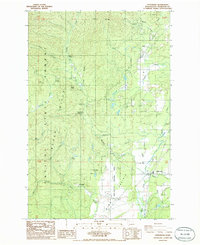
1986 Map of Littlerock
USGS Topo · Published 1986About this map
Capitol State Forest Black Hills dominates this mid-1980s terrain, where the logging history and natural curiosities of Thurston County intersect. The settlement of Littlerock sits at the eastern edge of the Mima Prairie, a landscape characterized by the unique geological formations preserved within the Mima Mounds Natural Area. To the west, the former lumber town of Bordeaux is situated near the confluence of Mima Creek and Waddell Creek, surrounded by timberlands and various campgrounds such as Bordeaux Campground and Margaret McKenny Campground. The map reveals a working landscape of resource extraction and recreation, with several Borrow Pits and Gravel Pits scattered near the Black River. High points like Mount Molly and Little Larch Mtn provide verticality to the forest, while local history is marked by a Cemetery near the community of Delphi.
Find a feature on this map
38 named features on this map. Tap any name to fly to it.
Don’t see what you’re looking for? This feature index may not catch every label — zoom into the map to look around manually.
Map Details
Editions of this 1986 Littlerock Map
2 editions found
Other maps of this area

1916 · Chehalis
USGS Topo · 1:125,000

1937 · Olympia
USGS Topo · 1:62,500

1939 · Shelton
USGS Topo · 1:62,500

1940 · Tenino
USGS Topo · 1:62,500

1941 · Gate
USGS Topo · 1:62,500

1944 · Tenino
USGS Topo · 1:62,500

1949 · Tenino
USGS Topo · 1:62,500

1949 · Olympia
USGS Topo · 1:62,500

1953 · Hoquiam
USGS Topo · 1:250,000

1953 · Rochester
USGS Topo · 1:62,500