
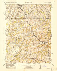
1944 Map of Littlestown
USGS Topo · Published 1944About this map
Littlestown anchors the northern boundary of this mid-1940s survey, where the Maryland and Pennsylvania state line bisects a landscape defined by milling and agriculture. The agricultural economy of Carroll and Adams counties is evident through the concentration of processing sites like the A W Feeser Packing Plant near Silver Run and the Pleasant Valley Canning Co to the south. Water power remains a visible legacy in the terrain, with Menges Mill, Arters Mill, and the Pipe Creek Flour Mill Ditch tracing the paths of Piney Creek and Big Pipe Creek. Local education and community life are well-documented through numerous rural schoolhouses, including Oak Grove School and the Charles Carroll High School. The map provides a detailed view of the road and rail network connecting Kingsdale and Union Mills during the final years of the Second World War.
Find a feature on this map
38 named features on this map. Tap any name to fly to it.
Don’t see what you’re looking for? This feature index may not catch every label — zoom into the map to look around manually.
Map Details
Editions of this 1944 Littlestown Map
2 editions found
Other maps of this area

1905 · Westminster
USGS Topo · 1:62,500

1908 · Gettysburg
USGS Topo · 1:62,500

1911 · Taneytown
USGS Topo · 1:62,500

1920 · Hanover
USGS Topo · 1:62,500

1922 · Hanover
USGS Topo · 1:62,500

1942 · Gettysburg
USGS Topo · 1:125,000

1944 · Manchester
USGS Topo · 1:31,680

1944 · Union Bridge
USGS Topo · 1:31,680

1944 · Gettysburg
USGS Topo · 1:31,680

1944 · New Windsor
USGS Topo · 1:31,680