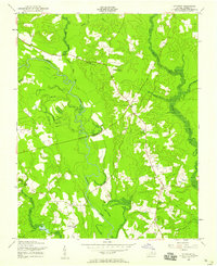
1956 Map of Littleton
USGS Topo · Published 1958About this map
The winding Nottoway River defines the rural landscape of Sussex County, carving a deep, meandering path through a mix of wooded bottomlands and upland clearings. Small agrarian centers like Homeville and Littleton anchor the community, connected by a network of light-duty and unimproved roads. The distribution of civic structures like the Plank Road Sch and Homeville Sch, along with houses of worship such as Easter Ch and Oak Grove Ch, reflects a classic mid-century Virginia pattern of decentralized, rural settlement. Navigational infrastructure is notably represented by the Patrick Henry Radio Range Sta, while the presence of several Gravel Pits suggests localized extraction near the river's edge. Waterways like Nibletts Mill Run and Cope Charles Spring Br drain the surrounding fields, highlighting the area's dependence on natural drainage for its agricultural viability.
Find a feature on this map
19 named features on this map. Tap any name to fly to it.
Don’t see what you’re looking for? This feature index may not catch every label — zoom into the map to look around manually.
Map Details
Editions of this 1956 Littleton Map
This is the sole edition of this map. No revisions or reprints were ever made.
Other maps of this area

1894 · Petersburg
USGS Topo · 1:62,500

1919 · Jarratt
USGS Topo · 1:62,500

1919 · Disputanta
USGS Topo · 1:62,500

1919 · Homeville
USGS Topo · 1:48,000

1920 · Homeville
USGS Topo · 1:62,500

1943 · Sebrell
USGS Topo · 1:31,680

1943 · Manry
USGS Topo · 1:31,680

1943 · Littleton
USGS Topo · 1:31,680

1943 · Vicksville
USGS Topo · 1:31,680

1943 · Richmond
USGS Topo · 1:250,000