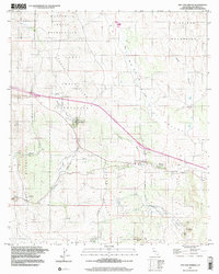
1997 Map of Live Oak Springs
USGS Topo · Published 2003About this map
Tecate Divide serves as the topographic backbone for this high-desert region of San Diego County, separating the drainages of Campo Creek and Walker Creek. This landscape is defined by its reservation lands, primarily the Manzanita Indian Reservation and La Posta Indian Reservation, which cover significant portions of the northern and western terrain. Small roadside settlements and travel stops like Live Oak Springs, Manzanita, and Boulevard follow the established transport corridors, anchored by local institutions such as the Clover Flat Sch and the St Carmel Cemetery. The map captures a moment of late 20th-century rural infrastructure, where isolated homesteads and wells are scattered across the Valley and among peaks like Music Mtn and Rattlesnake Mtn. Geographers and genealogists can trace the footprint of early San Diego backcountry life through these named landmarks and the winding path of Jewell Valley Creek.
Find a feature on this map
31 named features on this map. Tap any name to fly to it.
Don’t see what you’re looking for? This feature index may not catch every label — zoom into the map to look around manually.
Map Details
Editions of this 1997 Live Oak Springs Map
This is the sole edition of this map. No revisions or reprints were ever made.
Other maps of this area

1931 · Carrizo
USGS Topo · 1:125,000

1939 · Campo
USGS Topo · 1:62,500

1939 · Jacumba
USGS Topo · 1:62,500

1942 · Campo
USGS Topo · 1:62,500

1942 · Carrizo Mtn
USGS Topo · 1:62,500

1942 · Jacumba
USGS Topo · 1:62,500

1942 · Cuyapaipe
USGS Topo · 1:62,500

1950 · San Diego
USGS Topo · 1:250,000

1954 · San Diego
USGS Topo · 1:250,000

1955 · San Diego
USGS Topo · 1:250,000