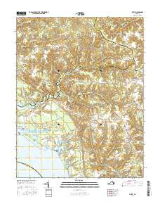
2016 Map of Lively
USGS Topo · Published 2016About this map
Belle Isle stands at the heart of this coastal Virginia landscape, where the northern shore of the Rappahannock River meets a network of tidal creeks and marshes. The area's agricultural and industrial history is visible through the numerous impoundments and water features that punctuate the interior, including Balls Millpond, Chinns Pond, and Blakemore Millpond. Small rural settlements like Morattico, Nuttsville, and Lively serve as local hubs, connected by a dense web of roads such as Morattico Rd and Belle Isle Rd. This survey documents a quiet riverine economy, with the landscape transitioning from the low-lying wetlands of Mulberry Cr and Luton Swamp to the higher ground of Lara and Robley. For those researching family history, the map precisely locates several community focal points including Bethel Cem, Norwood Cem, and Hopewell Cem.
Find a feature on this map
85 named features on this map. Tap any name to fly to it.
Don’t see what you’re looking for? This feature index may not catch every label — zoom into the map to look around manually.
Map Details
Editions of this 2016 Lively Map
This is the sole edition of this map. No revisions or reprints were ever made.
Other maps of this area

1916 · Kilmarnock
USGS Topo · 1:48,000

1917 · Heathsville
USGS Topo · 1:48,000

1917 · Urbanna
USGS Topo · 1:62,500

1917 · Morattico
USGS Topo · 1:62,500

1917 · Kilmarnock
USGS Topo · 1:62,500

1918 · Morattico
USGS Topo · 1:62,500

1926 · Morattico
USGS Topo · 1:62,500

1942 · Kilmarnock
USGS Topo · 1:62,500

1943 · Richmond
USGS Topo · 1:250,000

1944 · Morattico
USGS Topo · 1:31,680