
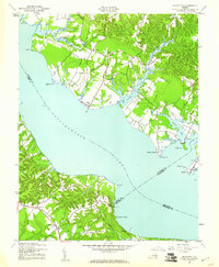
1944 Map of Morattico
USGS Topo · Published 1944About this map
The Rappahannock River serves as the central artery for this mid-century survey, dividing the Northern Neck from the Middle Peninsula. Along its banks, the river-centric economy of the 1940s is evident in landings such as Oakley Landing, Laytons Ldg, and Canoe House Ldg. This area, comprising parts of Richmond, Lancaster, Essex, and Middlesex counties, shows a landscape defined by tidal creeks and interior swamps like Myrtle Swamp and Lafont Swamp.
Find a feature on this map
51 named features on this map. Tap any name to fly to it.
Don’t see what you’re looking for? This feature index may not catch every label — zoom into the map to look around manually.
Map Details
Editions of this 1944 Morattico Map
2 editions found
Other maps of this area

1917 · Urbanna
USGS Topo · 1:62,500

1917 · Morattico
USGS Topo · 1:62,500

1918 · Tappahannock
USGS Topo · 1:62,500

1918 · Morattico
USGS Topo · 1:62,500

1919 · New Kent
USGS Topo · 1:62,500

1919 · Tappahannock
USGS Topo · 1:62,500

1926 · Morattico
USGS Topo · 1:62,500

1943 · Richmond
USGS Topo · 1:250,000

1944 · Tappahannock
USGS Topo · 1:31,680

1944 · Dunnsville
USGS Topo · 1:31,680