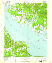
1944 Map of Morattico
USGS Topo · Published 1961About this map
The Rappahannock River dominates this mid-century landscape, acting as both a natural boundary and a thoroughfare for the waterfront communities of Richmond, Lancaster, Middlesex, and Essex Counties. Small riverfront settlements and landings like Sharps, Morattico, and Laytons Landing define the shoreline, reflecting an era when water-based commerce and transport remained central to Northern Neck life. Further inland, the map captures a rural social infrastructure of country schools and civic buildings, including Ebenezer Sch, School No 5, and the True Reformer Hall. These features, along with the Old Long Bridge spanning Farnham Creek, reveal a transitioning transportation network where older crossings and maritime points were being superseded by modern road systems. The complex finger-like estuaries of Richardson Creek and Morattico Creek highlight the deeply indented coastline of this Chesapeake Bay tributary region.
Find a feature on this map
40 named features on this map. Tap any name to fly to it.
Don’t see what you’re looking for? This feature index may not catch every label — zoom into the map to look around manually.
Map Details
Editions of this 1944 Morattico Map
2 editions found

Other maps of this area

1917 · Urbanna
USGS Topo · 1:62,500

1917 · Morattico
USGS Topo · 1:62,500

1918 · Tappahannock
USGS Topo · 1:62,500

1918 · Morattico
USGS Topo · 1:62,500

1919 · New Kent
USGS Topo · 1:62,500

1919 · Tappahannock
USGS Topo · 1:62,500

1926 · Morattico
USGS Topo · 1:62,500

1943 · Richmond
USGS Topo · 1:250,000

1944 · Tappahannock
USGS Topo · 1:31,680

1944 · Dunnsville
USGS Topo · 1:31,680