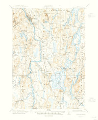
1912 Map of Livermore
USGS Topo · Published 1947About this map
The Androscoggin River carves a deep path through this central Maine landscape, serving as the primary corridor for industry and transit in the early twentieth century. Along its banks, the Maine Central RR connects established mill towns and rural depots, including the bustling industrial center at Livermore Falls and the riverside landing at Strickland. The map reveals a robust network of river-based infrastructure, from the Hillman Ferry to the Turner Bridge, reflecting a time before modern highway crossings dominated the valley.
Find a feature on this map
145 named features on this map. Tap any name to fly to it.
Don’t see what you’re looking for? This feature index may not catch every label — zoom into the map to look around manually.
Map Details
Editions of this 1912 Livermore Map
5 editions found
Other maps of this area

1892 · Gardiner
USGS Topo · 1:62,500

1892 · Augusta
USGS Topo · 1:62,500

1894 · Norridgewock
USGS Topo · 1:62,500

1898 · Norridgewock
USGS Topo · 1:62,500

1908 · Poland
USGS Topo · 1:62,500

1908 · Lewiston
USGS Topo · 1:62,500

1910 · Livermore
USGS Topo · 1:62,500

1911 · Buckfield
USGS Topo · 1:62,500

1912 · Livermore
USGS Topo · 1:62,500

1913 · Buckfield
USGS Topo · 1:62,500