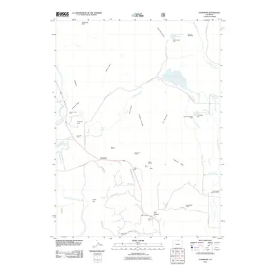
2011 Map of Livermore
USGS Topo · Published 2011About this map
Livermore serves as a central hub for this high-plains landscape, situated at the junction of Red Feather Lakes Rd and W County Rd 80. The terrain is defined by a series of dramatic ridges and canyons, including Grayback Ridge and the prominent Deadman Butte. This area has long supported diverse extractive activities, evidenced by the Deadman Butte Mine, Owl Canyon Mine, and various industrial sites like Roberts Quarry and the Folsom Point Diggings. Water management is essential to the region, with the North Poudre Ditch and Park Creek Lateral feeding a network of reservoirs including Park Creek Reservoir and Slab Canyon Reservoir. The southern reach is marked by the winding path of Owl Creek through the distinctive Owl Canyon near the small settlement of Rex.
Find a feature on this map
53 named features on this map. Tap any name to fly to it.
Don’t see what you’re looking for? This feature index may not catch every label — zoom into the map to look around manually.
Map Details
Editions of this 2011 Livermore Map
This is the sole edition of this map. No revisions or reprints were ever made.
Other maps of this area

1906 · Fort Collins
USGS Topo · 1:62,500

1907 · Livermore
USGS Topo · 1:125,000

1908 · Fort Collins
USGS Topo · 1:62,500

1909 · Livermore
USGS Topo · 1:125,000

1954 · Greeley
USGS Topo · 1:250,000

1957 · Greeley
USGS Topo · 1:250,000

1958 · Greeley
USGS Topo · 1:250,000

1960 · Livermore
USGS Topo · 1:24,000
1960 · Buckeye
USGS Topo · 1:24,000
1960 · Wellington
USGS Topo · 1:24,000