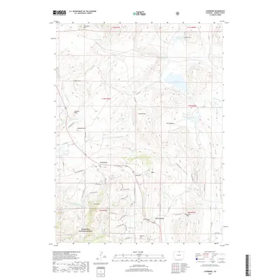
2019 Map of Livermore
USGS Topo · Published 2019About this map
Livermore and Owl Canyon anchor this Larimer County landscape, where the high plains meet the eastern slopes of the Roosevelt National Forest. The map documents a complex network of water management, from the N Poudre Canal to the Slab Canyon Reservoir and Park Creek Reservoir, illustrating the region's long-standing reliance on irrigation infrastructure. Notable landmarks like Steamboat Rock, Campbell Mtn, and Deadman Butte provide dramatic relief against the valley floor.
Find a feature on this map
62 named features on this map. Tap any name to fly to it.
Don’t see what you’re looking for? This feature index may not catch every label — zoom into the map to look around manually.
Map Details
Editions of this 2019 Livermore Map
This is the sole edition of this map. No revisions or reprints were ever made.
Other maps of this area

1906 · Fort Collins
USGS Topo · 1:62,500

1907 · Livermore
USGS Topo · 1:125,000

1908 · Fort Collins
USGS Topo · 1:62,500

1909 · Livermore
USGS Topo · 1:125,000

1954 · Greeley
USGS Topo · 1:250,000

1957 · Greeley
USGS Topo · 1:250,000

1958 · Greeley
USGS Topo · 1:250,000

1960 · Livermore
USGS Topo · 1:24,000
1960 · Buckeye
USGS Topo · 1:24,000
1960 · Wellington
USGS Topo · 1:24,000