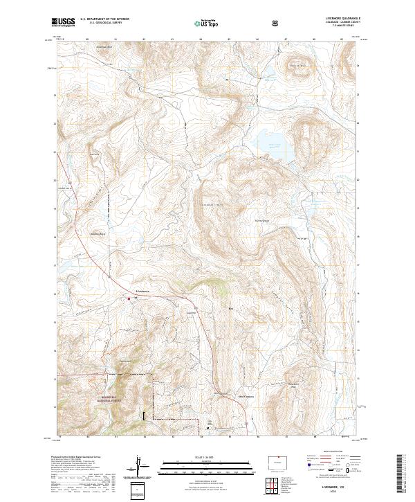
2022 Map of Livermore
USGS Topo · Published 2022About this map
Livermore and the surrounding high country of Roosevelt National Forest are defined by a complex network of canyons and water management infrastructure. This landscape is marked by substantial hydrological features, including the N Poudre Canal, Park Creek Reservoir, and the Park Cr Lateral, which illustrate the region's reliance on managed water resources. Historically significant landmarks such as the Eddie Hale Grave near Bonner Spring provide a rare glimpse into individual lives on the frontier, while the settlement at Rex sits nestled between Gage Hill and the broader Campbell Valley. The area is characterized by dramatic geology, from the heights of Steamboat Rock and Table Rock in the north to the sharp descent of Owl Canyon and Horsethief Pass in the south.
Find a feature on this map
66 named features on this map. Tap any name to fly to it.
Don’t see what you’re looking for? This feature index may not catch every label — zoom into the map to look around manually.
Map Details
Editions of this 2022 Livermore Map
This is the sole edition of this map. No revisions or reprints were ever made.
Other maps of this area

1906 · Fort Collins
USGS Topo · 1:62,500

1907 · Livermore
USGS Topo · 1:125,000

1908 · Fort Collins
USGS Topo · 1:62,500

1909 · Livermore
USGS Topo · 1:125,000

1954 · Greeley
USGS Topo · 1:250,000

1957 · Greeley
USGS Topo · 1:250,000

1958 · Greeley
USGS Topo · 1:250,000

1960 · Livermore
USGS Topo · 1:24,000
1960 · Buckeye
USGS Topo · 1:24,000
1960 · Wellington
USGS Topo · 1:24,000