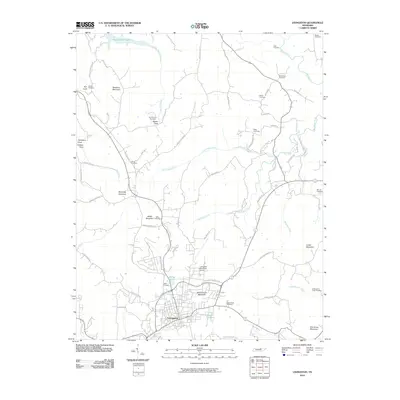
2010 Map of Livingston
USGS Topo · Published 2010About this map
Livingston serves as the central hub for this portion of Overton County, where the landscape transitions from established street grids to the rising elevations of Miller Mountain and Schoolhouse Mountain. Local genealogy is well-documented through a dense network of family-named burial grounds, including the Cash Cemetery near the heart of town and the Garrett Cemetery further north. These sites, along with the Nettlecarrier Creek Cemetery and Miller Cemetery, point to deep-rooted ancestral ties throughout the valleys.
Find a feature on this map
76 named features on this map. Tap any name to fly to it.
Don’t see what you’re looking for? This feature index may not catch every label — zoom into the map to look around manually.
Map Details
Editions of this 2010 Livingston Map
This is the sole edition of this map. No revisions or reprints were ever made.
Other maps of this area

1897 · Standingstone
USGS Topo · 1:125,000

1898 · Standingstone
USGS Topo · 1:125,000

1924 · Lillydale
USGS Topo · 1:62,500

1926 · Lillydale
USGS Topo · 1:62,500

1929 · Lillydale
USGS Topo · 1:62,500

1929 · Byrdstown
USGS Topo · 1:62,500

1944 · Livingston
USGS Topo · 1:24,000

1951 · Windle
USGS Topo · 1:24,000

1954 · Crawford
USGS Topo · 1:24,000
1955 · Hilham
USGS Topo · 1:24,000