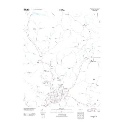
2013 Map of Livingston
USGS Topo · Published 2013About this map
Livingston serves as the central hub of this northern Tennessee landscape, where the street grid of the town center transitions into a network of mountain roads and rural settlements. The topography is defined by significant rises such as Schoolhouse Mountain and Reynolds Mountain, which overlook the winding drainage systems of Little Eagle Cr and Big Eagle Cr. To the north, the waters of Dale Hollow Lake reach into the map's corner, emphasizing the area's connection to the regional watershed. This 2013 survey illustrates a landscape where traditional landmarks like Garretts Mill and Howard Chapel persist alongside modern infrastructure, including the Livingston Municipal Airport. Smaller communities such as Free Communion, Unity, and Independence are connected by a web of local routes like Old Celina Rd and Upper Hilham Rd, reflecting a settlement pattern deeply influenced by the limestone coves and ridges of Overton County.
Find a feature on this map
182 named features on this map. Tap any name to fly to it.
Don’t see what you’re looking for? This feature index may not catch every label — zoom into the map to look around manually.
Map Details
Editions of this 2013 Livingston Map
This is the sole edition of this map. No revisions or reprints were ever made.
Other maps of this area

1897 · Standingstone
USGS Topo · 1:125,000

1898 · Standingstone
USGS Topo · 1:125,000

1924 · Lillydale
USGS Topo · 1:62,500

1926 · Lillydale
USGS Topo · 1:62,500

1929 · Lillydale
USGS Topo · 1:62,500

1929 · Byrdstown
USGS Topo · 1:62,500

1944 · Livingston
USGS Topo · 1:24,000

1951 · Windle
USGS Topo · 1:24,000

1954 · Crawford
USGS Topo · 1:24,000
1955 · Hilham
USGS Topo · 1:24,000