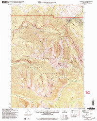
2000 Map of Livingston Peak
USGS Topo · Published 2005About this map
The high peaks of the Absaroka Range dominate this landscape south of the Yellowstone River valley, as documented in this 2000 revision. Rising to prominent summits like Livingston Peak, Elephanthead Mountain, and Mount Delano, the area is defined by the intersection of the Gallatin National Forest and the Absaroka-Beartooth Wilderness. The map reveals the administrative complexities of the Forest Service at the turn of the 21st century, showing the boundaries of the Livingston Ranger District and Beartooth Ranger District. While much of the terrain is accessible only by trail or drainage, Mission Creek Road provides a primary corridor into the mountain front. Sparse settlement is limited to the northern margins, notably at Triangle Ranch, while the interior remains a pristine network of basins and water bodies such as Blacktail Lake, West Baldy Basin, and East Baldy Basin.
Find a feature on this map
33 named features on this map. Tap any name to fly to it.
Don’t see what you’re looking for? This feature index may not catch every label — zoom into the map to look around manually.
Map Details
Editions of this 2000 Livingston Peak Map
This is the sole edition of this map. No revisions or reprints were ever made.
Other maps of this area

1891 · Livingston
USGS Topo · 1:250,000

1893 · Livingston
USGS Topo · 1:250,000

1940 · Mt. Cowen
USGS Topo · 1:62,500

1943 · Mt Cowen
USGS Topo · 1:62,500

1947 · Bozeman
USGS Topo · 1:250,000

1948 · Bozeman
USGS Topo · 1:250,000

1951 · Mount Rae
USGS Topo · 1:24,000

1951 · Brisbin
USGS Topo · 1:24,000

1951 · Livingston Peak
USGS Topo · 1:24,000

1951 · Elton
USGS Topo · 1:24,000