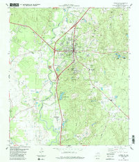
1984 Map of Livingston
USGS Topo · Published 1984About this map
Livingston serves as the regional hub in this mid-1980s Texas study, where the Southern Pacific railroad lines intersect with a landscape defined by significant water systems. The winding path of Long King Creek and Choates Creek shapes the local geography, providing drainage for a series of small lakes like Lake Barbara and Lake Bonnie. The map records a dense concentration of local heritage sites, including numerous country churches and memorial grounds that reflect the social fabric of the area.
Find a feature on this map
49 named features on this map. Tap any name to fly to it.
Don’t see what you’re looking for? This feature index may not catch every label — zoom into the map to look around manually.
Map Details
Editions of this 1984 Livingston Map
This is the sole edition of this map. No revisions or reprints were ever made.
Other maps of this area

1954 · Beaumont
USGS Topo · 1:250,000

1955 · New Willard
USGS Topo · 1:62,500

1957 · Beaumont
USGS Topo · 1:250,000

1958 · Livingston
USGS Topo · 1:62,500

1960 · Blanchard
USGS Topo · 1:24,000

1960 · Camilla
USGS Topo · 1:24,000

1961 · Onalaska
USGS Topo · 1:24,000

1984 · Soda
USGS Topo · 1:24,000

1984 · Beaumont
USGS Topo · 1:250,000
1984 · Leggett
USGS Topo · 1:24,000