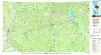
1992 Map of Livingston
USGS Topo · Published 1992About this map
Livingston serves as a central hub in this East Texas landscape, where the Southern Pacific railroad and major arteries like U S Highway 59 intersect. To the east, the Alabama and Coushatta Indian Reservation and the sprawling reaches of the Big Thicket National Preserve define the region's protected woodlands. The map captures the industrial and natural balance of the 1990s, featuring the Livingston Oil Field alongside significant water bodies like B A Steinhagen Lake and the Trinity River. Genealogists will find value in the precise locations of rural landmarks such as Holly Grove Ch, Bold Springs Cem, and the historic site of Peach Tree Village. From the timber-rich Angelina National Forest to small settlements like Dallardsville and Magnolia Springs, the map documents a transition point between the Piney Woods' forestry roots and modern infrastructure.
Find a feature on this map
181 named features on this map. Tap any name to fly to it.
Don’t see what you’re looking for? This feature index may not catch every label — zoom into the map to look around manually.
Map Details
Editions of this 1992 Livingston Map
This is the sole edition of this map. No revisions or reprints were ever made.
Other maps of this area

1927 · Lufkin 4-c
USGS Topo · 1:24,000

1928 · Zavalla 3-c
USGS Topo · 1:24,000

1928 · Lufkin 4-d
USGS Topo · 1:24,000

1931 · Zavalla
USGS Topo · 1:62,500

1932 · Manning
USGS Topo · 1:62,500

1943 · Liberty
USGS Topo · 1:125,000

1952 · Lake Charles
USGS Topo · 1:250,000

1953 · Alexandria
USGS Topo · 1:250,000

1953 · Palestine
USGS Topo · 1:250,000

1954 · Lake Charles
USGS Topo · 1:250,000