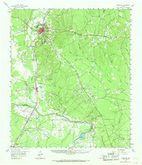
1958 Map of Livingston
USGS Topo · Published 1968About this map
The city of Livingston serves as a prominent hub in East Texas on this mid-century survey, defined by its position at the junction of the Texas and New Orleans and Southern Pacific railroads. The town's layout includes a High School, a Fairground, and a Livingston Lookout Tower, indicating its role as the administrative and social center of Polk County. Beyond the city limits, the landscape shifts toward industrial extraction, notably at the extensive Livingston Oil Field and Schwab Oil Field.
Find a feature on this map
71 named features on this map. Tap any name to fly to it.
Don’t see what you’re looking for? This feature index may not catch every label — zoom into the map to look around manually.
Map Details
Editions of this 1958 Livingston Map
2 editions found
Other maps of this area

1943 · Liberty
USGS Topo · 1:125,000

1954 · Beaumont
USGS Topo · 1:250,000

1955 · Saratoga
USGS Topo · 1:62,500

1955 · Camden
USGS Topo · 1:62,500

1955 · Rayburn
USGS Topo · 1:62,500

1955 · New Willard
USGS Topo · 1:62,500

1957 · Beaumont
USGS Topo · 1:250,000

1958 · Westcott
USGS Topo · 1:24,000

1958 · Livingston
USGS Topo · 1:62,500

1958 · Segno
USGS Topo · 1:62,500