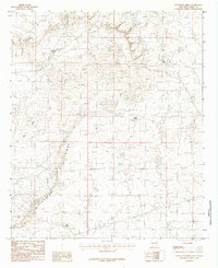
1985 Map of Livingston Ridge
USGS Topo · Published 1985About this map
Livingston Ridge dominates this high-desert landscape in Eddy County, serving as a prominent geographical divide above the surrounding flats. The map documents a sparsely populated but active resource area in the mid-1980s, where the natural terrain of the Maroon Cliffs meets industrial development. Evidence of local mining activity is clear near the northern edge of the ridge, marked by a significant deposit of Mine Tailings. Water management is critical in this arid environment, shown through a series of isolated reservoirs including Nova Tank, Hill Tank, and New Tank. The wide, seasonal drainage of Nash Draw cuts through the western portion of the quadrangle, illustrating the complex hydrology of the New Mexico desert floor during this era of survey.
Find a feature on this map
7 named features on this map. Tap any name to fly to it.
Don’t see what you’re looking for? This feature index may not catch every label — zoom into the map to look around manually.
Map Details
Editions of this 1985 Livingston Ridge Map
This is the sole edition of this map. No revisions or reprints were ever made.
Other maps of this area

1939 · Nash Draw
USGS Topo · 1:62,500

1942 · Clayton Basin
USGS Topo · 1:62,500

1943 · Clayton Basin
USGS Topo · 1:62,500

1943 · Nash Draw
USGS Topo · 1:62,500

1954 · Hobbs
USGS Topo · 1:250,000

1958 · Hobbs
USGS Topo · 1:250,000

1963 · Laguna Gatuna
USGS Topo · 1:62,500

1963 · Hat Mesa
USGS Topo · 1:62,500

1978 · Jal
USGS Topo · 1:100,000
1984 · Bootleg Ridge
USGS Topo · 1:24,000