
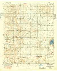
1943 Map of Clayton Basin
USGS Topo · Published 1943About this map
The industrial and ranching landscape of the Clayton Basin is defined by its potash production and isolated water sources in the years following the Great Depression. The Potash Co of America Mine stands as a significant landmark in the southwestern portion of the sheet, connected to the wider world via the Santa Fe Railroad (Oil City). This arid region in Eddy Co and Lea Co relies on scattered wells and ephemeral lakes like Walters Lake and Hackberry Lake for livestock and industrial use.
Find a feature on this map
23 named features on this map. Tap any name to fly to it.
Don’t see what you’re looking for? This feature index may not catch every label — zoom into the map to look around manually.
Map Details
Editions of this 1943 Clayton Basin Map
2 editions found
Other maps of this area

1939 · Carlsbad
USGS Topo · 1:62,500

1939 · Nash Draw
USGS Topo · 1:62,500

1942 · Clayton Basin
USGS Topo · 1:62,500

1943 · Carlsbad
USGS Topo · 1:62,500

1943 · Oil City
USGS Topo · 1:62,500

1943 · Nash Draw
USGS Topo · 1:62,500

1954 · Carlsbad
USGS Topo · 1:250,000

1954 · Hobbs
USGS Topo · 1:250,000

1955 · Red Lake SE
USGS Topo · 1:24,000

1958 · Carlsbad
USGS Topo · 1:250,000