
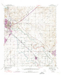
1939 Map of Carlsbad
USGS Topo · Published 1955About this map
The Pecos River carves a vital path through this arid Chihuahuan Desert landscape, anchoring the development of Carlsbad and the surrounding irrigation districts. In the late 1930s, the region’s complex water management system is on full display, from the northern Lake Avalon and Carlsbad National Wildlife Refuge down to the Harroun Dam. The map documents the industrial footprint of the era, specifically the U S Potash Co Refinery and several refineries linked by the Atchison Topeka and Santa Fe railroad line.
Find a feature on this map
37 named features on this map. Tap any name to fly to it.
Don’t see what you’re looking for? This feature index may not catch every label — zoom into the map to look around manually.
Map Details
Editions of this 1939 Carlsbad Map
2 editions found
Other maps of this area

1939 · Nash Draw
USGS Topo · 1:62,500

1942 · Clayton Basin
USGS Topo · 1:62,500

1943 · Carlsbad
USGS Topo · 1:62,500

1943 · Clayton Basin
USGS Topo · 1:62,500

1943 · Oil City
USGS Topo · 1:62,500

1943 · Nash Draw
USGS Topo · 1:62,500

1943 · West Carlsbad
USGS Topo · 1:62,500

1945 · West Carlsbad
USGS Topo · 1:62,500

1945 · Carlsbad Caverns East
USGS Topo · 1:62,500

1945 · Malaga
USGS Topo · 1:62,500