
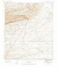
1945 Map of Carlsbad Caverns East
USGS Topo · Published 1961About this map
Carlsbad Caverns National Park defines the western landscape of this 1945 survey, featuring iconic subterranean landmarks such as Bat Cave, Chimney Cave, and the official Cavern Entrance. Outside the park boundaries, the settlement of White City sits as a gateway along the road toward the Black River. The eastern half of the map reveals a ranching economy centered around water sources, with family-named operations like W W Smith & Sons Ranch and Sims Ranch dotting the arid terrain.
Find a feature on this map
74 named features on this map. Tap any name to fly to it.
Don’t see what you’re looking for? This feature index may not catch every label — zoom into the map to look around manually.
Map Details
Editions of this 1945 Carlsbad Caverns East Map
2 editions found
Other maps of this area

1939 · Carlsbad
USGS Topo · 1:62,500

1940 · Bandanna Point
USGS Topo · 1:62,500

1940 · Carlsbad Caverns West
USGS Topo · 1:62,500

1943 · Carlsbad
USGS Topo · 1:62,500

1943 · Carlsbad Caverns West
USGS Topo · 1:62,500

1943 · Bandanna Point
USGS Topo · 1:62,500

1943 · West Carlsbad
USGS Topo · 1:62,500

1945 · West Carlsbad
USGS Topo · 1:62,500

1945 · Malaga
USGS Topo · 1:62,500

1946 · Malaga
USGS Topo · 1:62,500