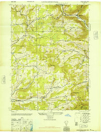
1946 Map of Livingstonville
USGS Topo · Published 1946About this map
Livingstonville and Broome Center anchor this mid-1940s landscape, where the northern Catskills meet the administrative borders of Schoharie, Albany, and Greene Counties. The terrain is defined by significant elevations like Leonard Hill, South Mountain, and Steenburg Mtn, with the deep valleys of Catskill Creek and Manor Kill dictating the placement of early settlements and road networks.
Find a feature on this map
34 named features on this map. Tap any name to fly to it.
Don’t see what you’re looking for? This feature index may not catch every label — zoom into the map to look around manually.
Map Details
Editions of this 1946 Livingstonville Map
This is the sole edition of this map. No revisions or reprints were ever made.
Other maps of this area

1893 · Durham
USGS Topo · 1:62,500

1894 · Durham
USGS Topo · 1:62,500

1898 · Schoharie
USGS Topo · 1:62,500

1900 · Schoharie
USGS Topo · 1:62,500

1900 · Berne
USGS Topo · 1:62,500

1901 · Gilboa
USGS Topo · 1:62,500

1903 · Gilboa
USGS Topo · 1:62,500

1903 · Berne
USGS Topo · 1:62,500

1943 · Breakabeen
USGS Topo · 1:24,000
1944 · Middleburgh
USGS Topo · 1:24,000