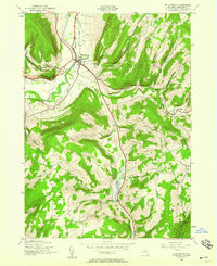
1944 Map of Middleburgh
USGS Topo · Published 1959About this map
Middleburg and the surrounding Catskill foothills appear here just before the mid-century, defined by a landscape of high ridges and narrow agricultural valleys. The topography is dominated by dramatic elevations like Vromans Nose and Hony Hill, which flank the winding path of Schoharie Creek. The settlement pattern follows the waterways and gaps, with smaller communities such as Huntersland and Franklinton serving as local hubs for the upland farms.
Find a feature on this map
32 named features on this map. Tap any name to fly to it.
Don’t see what you’re looking for? This feature index may not catch every label — zoom into the map to look around manually.
Map Details
Editions of this 1944 Middleburgh Map
4 editions found
Other maps of this area

1893 · Durham
USGS Topo · 1:62,500

1894 · Durham
USGS Topo · 1:62,500

1898 · Schoharie
USGS Topo · 1:62,500

1900 · Schoharie
USGS Topo · 1:62,500

1900 · Schoharie
USGS Topo · 1:31,680

1900 · Berne
USGS Topo · 1:62,500

1901 · Gilboa
USGS Topo · 1:62,500

1903 · Gilboa
USGS Topo · 1:62,500

1903 · Berne
USGS Topo · 1:62,500

1943 · Cobleskill
USGS Topo · 1:24,000