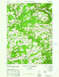
1962 Map of Livingstonville
USGS Topo · Published 1962About this map
Livingstonville sits at the intersection of rural life and the northern Catskill foothills, centered on the winding Catskill Creek valley. This 1940s-era fieldwork, published in the early 1960s, documents a landscape shaped by narrow agricultural valleys and significant elevation changes. Small rural hubs like Broome Center and Conesville are connected by a network of local roads that follow natural drainage patterns such as the Keyser Kill and Manor Kill. The map provides a look at the social infrastructure of Schoharie County, specifically the distribution of local education and faith through features like School No 9, School No 12, and the Scott Patent Ch. Topographical markers like Leonard Hill and High Knob dominate the interior, while family history is preserved in the Keyser Cem and Ellis Cem. The boundary lines crossing these peaks reflect the complex political divisions between Schoharie, Albany, and Greene counties.
Find a feature on this map
31 named features on this map. Tap any name to fly to it.
Don’t see what you’re looking for? This feature index may not catch every label — zoom into the map to look around manually.
Map Details
Editions of this 1962 Livingstonville Map
This is the sole edition of this map. No revisions or reprints were ever made.
Other maps of this area

1893 · Durham
USGS Topo · 1:62,500

1894 · Durham
USGS Topo · 1:62,500

1898 · Schoharie
USGS Topo · 1:62,500

1900 · Schoharie
USGS Topo · 1:62,500

1900 · Berne
USGS Topo · 1:62,500

1901 · Gilboa
USGS Topo · 1:62,500

1903 · Gilboa
USGS Topo · 1:62,500

1903 · Berne
USGS Topo · 1:62,500

1943 · Breakabeen
USGS Topo · 1:24,000
1944 · Middleburgh
USGS Topo · 1:24,000