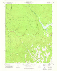
1973 Map of Lobelia
USGS Topo · Published 1977About this map
Lobelia sits at the southern end of a complex drainage basin where the highlands of the Monongahela National Forest meet the rolling valley floors. This 1970s landscape is defined by its transition from high ridges like the Kennison Mountains and Sugartree Bench Mtn to the unique wetlands of the Cranberry Glades Botanical Area. The map records a mix of natural conservation and active land use, including the Falls of Hills Creek and a localized Strip Mine near Rocky Knob. Small-scale settlement is clustered around the Emmanuel Ch, while the northern reaches remain dominated by wilderness trails like the Kennison Mountain Trail and fire suppression infrastructure, evidenced by the Mikes Knob Lookout Tower. Researchers will find evidence of the region's developing recreation economy through the presence of the Visitor Center and various designated scenic areas.
Find a feature on this map
61 named features on this map. Tap any name to fly to it.
Don’t see what you’re looking for? This feature index may not catch every label — zoom into the map to look around manually.
Map Details
Editions of this 1973 Lobelia Map
This is the sole edition of this map. No revisions or reprints were ever made.
Other maps of this area

1891 · Huntersville
USGS Topo · 1:125,000

1894 · Huntersville
USGS Topo · 1:125,000

1915 · Webster Springs
USGS Topo · 1:48,000

1918 · Webster Springs
USGS Topo · 1:62,500

1923 · Lobelia
USGS Topo · 1:48,000

1923 · Marlinton
USGS Topo · 1:48,000

1923 · Mingo
USGS Topo · 1:48,000

1925 · Mingo
USGS Topo · 1:62,500

1925 · Marlinton
USGS Topo · 1:62,500

1925 · Lobelia
USGS Topo · 1:62,500