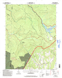
1995 Map of Lobelia
USGS Topo · Published 1998About this map
Monongahela National Forest dominates this highland landscape, where the Cranberry Wilderness meets the specialized ecosystems of the Cranberry Glades Botanical Area. The map reveals a transition from the preserved natural features of the Falls of Hills Creek Scenic Area to the agricultural and settlement patterns of the Little Levels. The small community of Lobelia is situated at the southern edge, supported by landmarks like Emmanuel Ch and a local Cem. The area's geography is defined by high ridges such as Kennison Mtn and Spring Mountain, while the industrial history of the region is briefly noted by a Strip Mine on Sugartree Beach Mtn. A network of forest routes, including the Kennison Mtn Trail and Dogway Road, provides the primary access through this complex drainage system of the Cranberry River and North Fork Cherry River.
Find a feature on this map
60 named features on this map. Tap any name to fly to it.
Don’t see what you’re looking for? This feature index may not catch every label — zoom into the map to look around manually.
Map Details
Editions of this 1995 Lobelia Map
This is the sole edition of this map. No revisions or reprints were ever made.
Other maps of this area

1891 · Huntersville
USGS Topo · 1:125,000

1894 · Huntersville
USGS Topo · 1:125,000

1915 · Webster Springs
USGS Topo · 1:48,000

1918 · Webster Springs
USGS Topo · 1:62,500

1923 · Lobelia
USGS Topo · 1:48,000

1923 · Marlinton
USGS Topo · 1:48,000

1923 · Mingo
USGS Topo · 1:48,000

1925 · Mingo
USGS Topo · 1:62,500

1925 · Marlinton
USGS Topo · 1:62,500

1925 · Lobelia
USGS Topo · 1:62,500