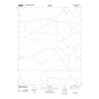
2010 Map of Loco Arroyo
USGS Topo · Published 2010About this map
Herrera Cemetery sits alone in a high-desert landscape defined by a complex network of seasonal drainage channels in this northern New Mexico survey. The terrain is dominated by the volcanic rise of Cerrito Negro in the northeast and a series of dry washes including Loco Arroyo, Kappis Arroyo, and Spring Arroyo. These arroyos carve the landscape between established routes like Tinaja Rd and County Road A 39. The map records a sparsely populated region of Colfax County where the natural topography dictates the few ranch roads and property boundaries. To the south, Ladd Arroyo and Rondeau Creek continue the pattern of intermittent waterways that support the area's grazing lands. This documentation is particularly useful for identifying isolated family sites and landmarks in an area where few formal structures exist.
Find a feature on this map
13 named features on this map. Tap any name to fly to it.
Don’t see what you’re looking for? This feature index may not catch every label — zoom into the map to look around manually.
Map Details
Editions of this 2010 Loco Arroyo Map
This is the sole edition of this map. No revisions or reprints were ever made.
Other maps of this area

1915 · Koehler
USGS Topo · 1:62,500

1917 · Koehler
USGS Topo · 1:62,500

1954 · Raton
USGS Topo · 1:250,000

1958 · Raton
USGS Topo · 1:250,000

1965 · Sauble Circle Dot Ranch
USGS Topo · 1:24,000

1965 · Abbott NW
USGS Topo · 1:24,000

1965 · French
USGS Topo · 1:24,000

1971 · Tres Hermanos Peak
USGS Topo · 1:24,000
1971 · Eagle Tail Mountain
USGS Topo · 1:24,000
1971 · Loco Arroyo
USGS Topo · 1:24,000