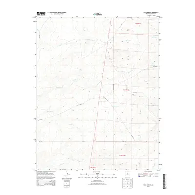
2013 Map of Loco Arroyo
USGS Topo · Published 2013About this map
Loco Arroyo and Kappis Arroyo wind through this high-plains landscape of Colfax County, where the dry drainage networks define the local topography. This 2013 survey by the U.S. Geological Survey illustrates a sparsely populated ranching and grazing region, punctuated by isolated features like the Herrera Cem located near Eagle Tail Rd. The terrain is marked by significant elevations such as Cerriot Negro in the northern portion of the quadrangle.
Find a feature on this map
18 named features on this map. Tap any name to fly to it.
Don’t see what you’re looking for? This feature index may not catch every label — zoom into the map to look around manually.
Map Details
Editions of this 2013 Loco Arroyo Map
This is the sole edition of this map. No revisions or reprints were ever made.
Other maps of this area

1915 · Koehler
USGS Topo · 1:62,500

1917 · Koehler
USGS Topo · 1:62,500

1954 · Raton
USGS Topo · 1:250,000

1958 · Raton
USGS Topo · 1:250,000

1965 · Sauble Circle Dot Ranch
USGS Topo · 1:24,000

1965 · Abbott NW
USGS Topo · 1:24,000

1965 · French
USGS Topo · 1:24,000

1971 · Tres Hermanos Peak
USGS Topo · 1:24,000
1971 · Eagle Tail Mountain
USGS Topo · 1:24,000
1971 · Loco Arroyo
USGS Topo · 1:24,000