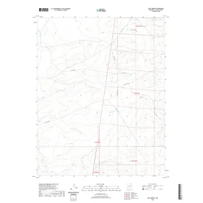
2020 Map of Loco Arroyo
USGS Topo · Published 2020About this map
Loco Arroyo and a network of seasonal watercourses define this high-plains landscape in northeastern New Mexico. The terrain is marked by the presence of Cerriot Negro in the northeast, overlooking a drainage system that includes Kappis Arroyo, Spring Arroyo, and Ladd Arroyo. These intermittent streams flow through a region primarily organized by the Public Land Survey System, with boundaries for townships like t27n r24e clearly delineated. For genealogists and local historians, the Herrera Cem provides a significant point of reference in an otherwise sparsely populated area. The human footprint is further traced through cattle-country infrastructure such as Eagle Tail Rd and the Maxwell Cutoff, while the Red River Ditch in the northwest corner points to the area's agricultural water management history.
Find a feature on this map
18 named features on this map. Tap any name to fly to it.
Don’t see what you’re looking for? This feature index may not catch every label — zoom into the map to look around manually.
Map Details
Editions of this 2020 Loco Arroyo Map
This is the sole edition of this map. No revisions or reprints were ever made.
Other maps of this area

1915 · Koehler
USGS Topo · 1:62,500

1917 · Koehler
USGS Topo · 1:62,500

1954 · Raton
USGS Topo · 1:250,000

1958 · Raton
USGS Topo · 1:250,000

1965 · Sauble Circle Dot Ranch
USGS Topo · 1:24,000

1965 · Abbott NW
USGS Topo · 1:24,000

1965 · French
USGS Topo · 1:24,000

1971 · Tres Hermanos Peak
USGS Topo · 1:24,000
1971 · Eagle Tail Mountain
USGS Topo · 1:24,000
1971 · Loco Arroyo
USGS Topo · 1:24,000