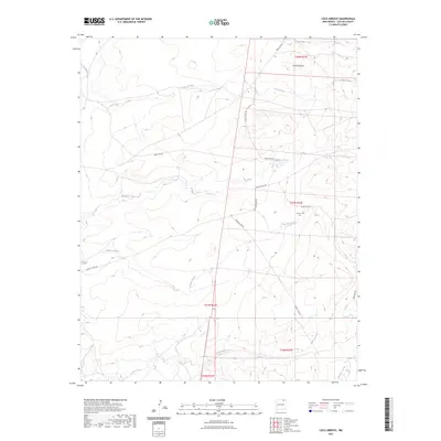
2023 Map of Loco Arroyo
USGS Topo · Published 2023About this map
Herrera Cem sits alone in the southeastern reaches of this high-plains landscape, serving as a primary point of interest for genealogists and local historians. This corner of Colfax County is defined by a network of seasonal watercourses and drainage channels, including Loco Arroyo, Kappis Arroyo, and Ladd Arroyo. These arroyos indicate the intermittent hydrology of the region, where water management is crucial as evidenced by the Red River Ditch. The terrain is punctuated by significant landmarks like Cerriot Negro in the north, while a sparse road system including Eagle Tail Rd and the Maxwell Cutoff provides the only formal access through the expansive range lands. The map illustrates the continuing importance of large-scale land divisions, showing the boundaries of several townships and ranges such as t27n r24e.
Find a feature on this map
18 named features on this map. Tap any name to fly to it.
Don’t see what you’re looking for? This feature index may not catch every label — zoom into the map to look around manually.
Map Details
Editions of this 2023 Loco Arroyo Map
This is the sole edition of this map. No revisions or reprints were ever made.
Other maps of this area

1915 · Koehler
USGS Topo · 1:62,500

1917 · Koehler
USGS Topo · 1:62,500

1954 · Raton
USGS Topo · 1:250,000

1958 · Raton
USGS Topo · 1:250,000

1965 · Sauble Circle Dot Ranch
USGS Topo · 1:24,000

1965 · Abbott NW
USGS Topo · 1:24,000

1965 · French
USGS Topo · 1:24,000

1971 · Tres Hermanos Peak
USGS Topo · 1:24,000
1971 · Eagle Tail Mountain
USGS Topo · 1:24,000
1971 · Loco Arroyo
USGS Topo · 1:24,000