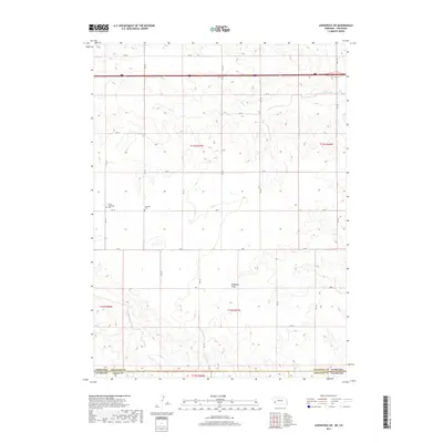
2017 Map of Lodgepole SW
USGS Topo · Published 2017About this map
The High Plains borderlands between Logan County, Colorado and Cheyenne County, Nebraska are defined by a sparse network of section-line roads and seasonal drainage systems. Cultural heritage is anchored in the presence of the Czech Slovensky Cem and Swankee Cem, both situated near the state line in the northern reaches of the quadrangle. These sites reflect the early twentieth-century ethnic settlement patterns and family genealogy of the region. The landscape is predominantly agrarian, carved by ephemeral waterways such as Cow Creek and the meandering Cottonwood Creek. The vast, open terrain is further articulated by Sedgwick Draw, illustrating the subtle topographic shifts characteristic of this portion of the Great Plains where the road grid, from RD 18 to RD 4, imposes a strict geometry on the natural drainage basins.
Find a feature on this map
22 named features on this map. Tap any name to fly to it.
Don’t see what you’re looking for? This feature index may not catch every label — zoom into the map to look around manually.
Map Details
Editions of this 2017 Lodgepole SW Map
This is the sole edition of this map. No revisions or reprints were ever made.
Other maps of this area

1899 · Sidney
USGS Topo · 1:125,000

1953 · Twin Buttes
USGS Topo · 1:24,000

1953 · Julesburg Reservoir
USGS Topo · 1:24,000

1953 · Sedgwick
USGS Topo · 1:24,000

1954 · Sterling
USGS Topo · 1:250,000

1954 · Scottsbluff
USGS Topo · 1:250,000

1958 · Scottsbluff
USGS Topo · 1:250,000

1958 · Sterling
USGS Topo · 1:250,000
1971 · Twin Buttes
USGS Topo · 1:24,000

1972 · Lodgepole
USGS Topo · 1:24,000