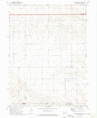
1972 Map of Lodgepole SW
USGS Topo · Published 1975About this map
The Nebraska-Colorado state line bisects this 1972 survey, capturing a high plains landscape defined by drainage patterns and early cultural sites. The rolling terrain is marked by the seasonal flow of Cow Creek in the north and Cottonwood Creek in the south, which cut through the open country of Cheyenne County and Logan County. Human impact on this rural expanse is most visible in the proximity of two historic burial grounds, the Czech Slovensky Cem and Swankee Cem, providing specific points of interest for genealogists tracing family histories in this border region. Transport infrastructure is represented by the path of Interstate 80 cutting across the northern portion of the map, while several Gravel Pits indicate local natural resource extraction during the early 1970s.
Find a feature on this map
13 named features on this map. Tap any name to fly to it.
Don’t see what you’re looking for? This feature index may not catch every label — zoom into the map to look around manually.
Map Details
Editions of this 1972 Lodgepole SW Map
This is the sole edition of this map. No revisions or reprints were ever made.
Other maps of this area

1899 · Sidney
USGS Topo · 1:125,000

1953 · Twin Buttes
USGS Topo · 1:24,000

1953 · Julesburg Reservoir
USGS Topo · 1:24,000

1953 · Sedgwick
USGS Topo · 1:24,000

1954 · Sterling
USGS Topo · 1:250,000

1954 · Scottsbluff
USGS Topo · 1:250,000

1958 · Scottsbluff
USGS Topo · 1:250,000

1958 · Sterling
USGS Topo · 1:250,000
1971 · Twin Buttes
USGS Topo · 1:24,000

1972 · Lodgepole
USGS Topo · 1:24,000