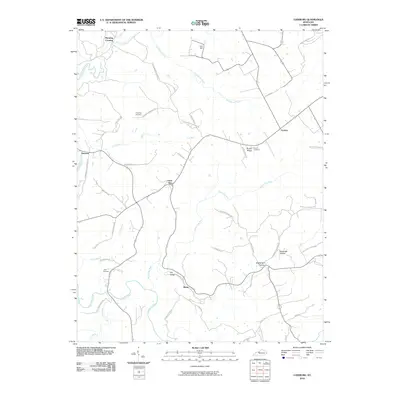
2010 Map of Lodiburg
USGS Topo · Published 2010About this map
Union Star and Frymire anchor this corner of Breckinridge County, where the landscape is defined by the winding paths of Yellowbank Creek and Sinking Creek. The area maintains its rural character through numerous family-named landmarks and historical burial grounds, including Shelman Cemetery and Bruner Cemetery. The topography transitions from the high point of Levi Hill down into Dry Valley and across Bruner Ridge. Roadways often follow the names of early local residents and destinations, such as Still's Rd and Ammons Stephensport Ln, reflecting a community structure tied to land ownership and local travel routes. The smaller settlements of Ammons and Mystic further illustrate the distribution of long-established rural hamlets throughout the territory.
Find a feature on this map
49 named features on this map. Tap any name to fly to it.
Don’t see what you’re looking for? This feature index may not catch every label — zoom into the map to look around manually.
Map Details
Editions of this 2010 Lodiburg Map
This is the sole edition of this map. No revisions or reprints were ever made.
Other maps of this area

1928 · Hardinsburg
USGS Topo · 1:48,000

1931 · Hardinsburg
USGS Topo · 1:62,500

1934 · Cannelton
USGS Topo · 1:62,500

1947 · Irvington
USGS Topo · 1:24,000

1947 · Lodiburg
USGS Topo · 1:24,000

1947 · Hardinsburg
USGS Topo · 1:24,000

1947 · Garfield
USGS Topo · 1:24,000

1947 · Hardinsburg
USGS Topo · 1:62,500
1950 · New Amsterdam
USGS Topo · 1:24,000

1950 · Alton
USGS Topo · 1:62,500