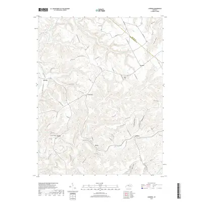
2019 Map of Lodiburg
USGS Topo · Published 2019About this map
Union Star and Lodiburg serve as central hubs in this landscape of the Pennyroyal Plateau, where the headwaters of Yellowbank Creek and Sinking Creek carve deep into the Kentucky limestone. The terrain is defined by a dense network of hollows and ridges, including Prather Hollow and Bruner Ridge, which have historically dictated the winding path of local transit. Numerous family-named routes such as Dutschke Mill Ln, Jake Horsley Rd, and Seaton Hanks Rd reflect a long-standing pattern of rural landownership and family farmsteads. Local genealogy is well-preserved through several small burial sites, including Shellman Cem, Bruner Cem, and Jolly Cem. Small communities like Ammons, Frymire, and Sample are linked by these narrow backroads, showing a settlement pattern that remains largely tied to the topography of the many creek branches like Lick Run and Sugar Tree Run.
Find a feature on this map
72 named features on this map. Tap any name to fly to it.
Don’t see what you’re looking for? This feature index may not catch every label — zoom into the map to look around manually.
Map Details
Editions of this 2019 Lodiburg Map
This is the sole edition of this map. No revisions or reprints were ever made.
Other maps of this area

1928 · Hardinsburg
USGS Topo · 1:48,000

1931 · Hardinsburg
USGS Topo · 1:62,500

1934 · Cannelton
USGS Topo · 1:62,500

1947 · Irvington
USGS Topo · 1:24,000

1947 · Lodiburg
USGS Topo · 1:24,000

1947 · Hardinsburg
USGS Topo · 1:24,000

1947 · Garfield
USGS Topo · 1:24,000

1947 · Hardinsburg
USGS Topo · 1:62,500
1950 · New Amsterdam
USGS Topo · 1:24,000

1950 · Alton
USGS Topo · 1:62,500