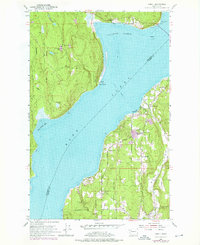
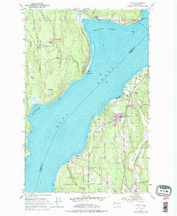
1953 Map of Lofall
USGS Topo · Published 1976About this map
Hood Canal divides the rugged coastlines of Jefferson and Kitsap counties, serving as a central maritime corridor for the small communities of Lofall, Shine, and Vinland. This mid-century survey reveals a landscape of transition where early industrial sites like Gravel Pits operate near recreational landmarks such as Kitsap Memorial State Park. The Jefferson County side is defined by the high ground of the Toandos Peninsula, dotted with small interior waters like Pheasant Lake, Lost Lake, and Twin Lakes. On the eastern shore, the Kitsap side shows more concentrated development along the Big Valley road network, including the Grange Hall and Breidablick. A notable maritime connection is the Ferry crossing that linked these shores before modern infrastructure was fully established, while the southern reaches are marked by the presence of a Naval Reservation. Local social life is evidenced by the Vinland Church and the Standard Sch in Shine.
Find a feature on this map
33 named features on this map. Tap any name to fly to it.
Don’t see what you’re looking for? This feature index may not catch every label — zoom into the map to look around manually.
Map Details
Editions of this 1953 Lofall Map
5 editions found
Other maps of this area

1936 · Point Misery
USGS Topo · 1:62,500

1937 · Port Orchard
USGS Topo · 1:62,500

1937 · Port Gamble
USGS Topo · 1:62,500

1940 · Port Gamble
USGS Topo · 1:62,500

1940 · Point Misery
USGS Topo · 1:62,500

1940 · Quilcene
USGS Topo · 1:62,500

1953 · Seabeck
USGS Topo · 1:24,000

1953 · Poulsbo
USGS Topo · 1:24,000

1953 · Quilcene
USGS Topo · 1:24,000

1953 · Hansville
USGS Topo · 1:24,000